Property Record
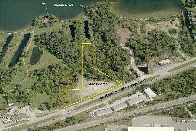
5815 Us Highway 1, Rockledge, FL 32955


NEARBY LISTINGS FOR SALE OR LEASE
Property Detail
5815 Us Highway 1
Palm Bay-Melbourne-Titusville, FL
Acreage
26-36-01-00-00002.0-0000.00
PART OF GOVT LOTS 1 & 2 LYING EAST OF US HIGHWAY 1 AS DESC IN ORB 1856 PG 50 & ORB 1917 PG 231 ALSO INCL PART OF W 1/2 OF NW 1/4 E OF HWY EXC DB 360 PG 266 PAR 3 & 251
Officebuilding
Brevard
AE
Florida
12009C0445H
1,2
2024
3.38 AC
2025
Brevard County
062800
Orlando
14,956 SF
DEMOGRAPHICS near 5815 Us Highway 1
1 Mile
3 Mile
5 Mile
2024 Total Population
4,077
31,487
80,640
2029 Population
4,388
34,190
88,513
Pop Growth 2024-2029
+ 7.63%
+ 8.58%
+ 9.76%
Average Age
46
47
46
2024 Total Households
1,667
13,597
33,164
HH Growth 2024-2029
+ 7.44%
+ 8.48%
+ 9.46%
Median Household Inc
$119,074
$91,369
$96,454
Avg Household Size
2.40
2.30
2.40
2024 Avg HH Vehicles
2.00
2.00
2.00
Median Home Value
$342,900
$338,796
$369,935
Median Year Built
1994
1996
2000
Nearby Places
Map Layers
Map Styles
 Street
 Aerial
- Restaurants
- Banks
- Shops
- Fitness
- Groceries
PUBLIC TRANSPORTATION
AIRPORT
Melbourne Orlando International
DRIVE
WALK
Distance
Melbourne Orlando International
27 min
14.3 mi
Freight Ports
Port Canaveral
DRIVE
WALK
Distance
Port Canaveral
30 min
19.5 mi
Nearby Properties
Address
Land Use
TOTAL SIZE
Lot Size
Zoning
Address
Land Use
TOTAL SIZE
Lot Size
Zoning
520,272 SF
17.31 AC
Address
Land Use
TOTAL SIZE
Lot Size
Zoning
354,864 SF
26.76 AC
PIP
Address
Land Use
TOTAL SIZE
Lot Size
Zoning
460,019 SF
11.64 AC
Address
Land Use
TOTAL SIZE
Lot Size
Zoning
406,986 SF
30.50 AC
PUD
Address
Land Use
TOTAL SIZE
Lot Size
Zoning
381,303 SF
9.93 AC
Address
Land Use
TOTAL SIZE
Lot Size
Zoning
395,806 SF
12.95 AC
Address
Land Use
TOTAL SIZE
Lot Size
Zoning
358,615 SF
14.78 AC
PUD
Address
Land Use
TOTAL SIZE
Lot Size
Zoning
276,647 SF
2.39 AC
Address
Land Use
TOTAL SIZE
Lot Size
Zoning
353,805 SF
44.02 AC
PUD
Address
Land Use
TOTAL SIZE
Lot Size
Zoning
269,541 SF
17.80 AC
PUD
Address
Land Use
TOTAL SIZE
Lot Size
Zoning
134,562 SF
18.25 AC
BU1
Address
Land Use
TOTAL SIZE
Lot Size
Zoning
375,112 SF
30.84 AC
PUD
Address
Land Use
TOTAL SIZE
Lot Size
Zoning
113,498 SF
37.57 AC
PUD
Address
Land Use
TOTAL SIZE
Lot Size
Zoning
96,110 SF
49.65 AC
INH
Address
Land Use
TOTAL SIZE
Lot Size
Zoning
110,902 SF
10.67 AC
Address
Land Use
TOTAL SIZE
Lot Size
Zoning
213,915 SF
27.13 AC
BU1
Address
Land Use
TOTAL SIZE
Lot Size
Zoning
133,137 SF
10.59 AC
PUD
Address
Land Use
TOTAL SIZE
Lot Size
Zoning
135,320 SF
16.54 AC
BU1
Address
Land Use
TOTAL SIZE
Lot Size
Zoning
104,705 SF
15.14 AC
PUD
Address
Land Use
TOTAL SIZE
Lot Size
Zoning
69,560 SF
9 AC
PUD
Address
Land Use
TOTAL SIZE
Lot Size
Zoning
170,721 SF
28.52 AC
PIP
Address
Land Use
TOTAL SIZE
Lot Size
Zoning
75,200 SF
4.14 AC
Address
Land Use
TOTAL SIZE
Lot Size
Zoning
68,428 SF
3.66 AC
Address
Land Use
TOTAL SIZE
Lot Size
Zoning
83,420 SF
5.94 AC
PUD
Address
Land Use
TOTAL SIZE
Lot Size
Zoning
91,470 SF
3.01 AC
BU1
Address
Land Use
TOTAL SIZE
Lot Size
Zoning
178,191 SF
18.19 AC
TU-2
Address
Land Use
TOTAL SIZE
Lot Size
Zoning
54,114 SF
11.48 AC
Address
Land Use
TOTAL SIZE
Lot Size
Zoning
222,414 SF
13.13 AC
BU1
Address
Land Use
TOTAL SIZE
Lot Size
Zoning
51,042 SF
1.70 AC
TU-2
Address
Land Use
TOTAL SIZE
Lot Size
Zoning
57,069 SF
5.89 AC
The World's #1 Commercial Real Estate Marketplace
Connect with us
© 2025 CoStar Group
The information above has been obtained from sources believed reliable. While we do not doubt its accuracy we have not verified it and make no guarantee, warranty or representation about it. It is your responsibility to independently confirm its accuracy and completeness. Any projections, opinions, assumptions, or estimates used are for example only and do not represent the current or future performance of the property. The value of this transaction to you depends on tax and other factors which should be evaluated by your tax, financial, and legal advisors. You and your advisors should conduct a careful, independent investigation of the property to determine to your satisfaction the suitability of the property for your needs.